The Indus Basin Project is a basically a water control project that came in to existence a result from a treaty and this famous treaty is known as Indus Water Treaty. This treaty was signed between India and Pakistan in the year 1960. According to this treaty (which this treaty guaranteed), Pakistan would receive water from the Indus River independent from upstream control by India. The construction of two main dams, the Mangla Dam which has been built on Jhelum River and the Tarbela Dam which has been constructed on Indus River was the main component of this treaty.
History of Indus Valley and Its Civilization
There are different types of research reports that have been written on the history and civilization of Indus valley. These research reports have been concluded the fact that the ancient people of the valley of Indus were quite expert in the field and occupation of agriculture as compared to the civilization of contemporary period in Egypt and Mesopotamia.
These research reports have also shown this fact that peoples of Indus valley were the first sedentary farmers of the world. The richness and wealth of the Indus valley was the greed of the foreigners.

Background of Indus Basin System
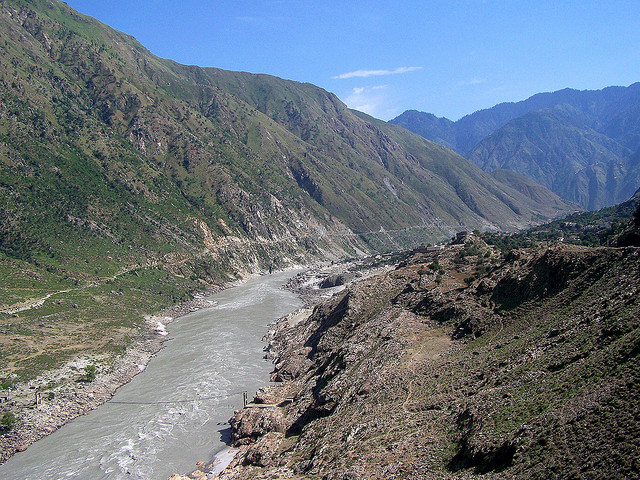
The history and background of Indus Basin System is quite wide and its roots have been spread to different segments. There are different types of research reports that have been written on this project and they concluded the fact that the Indus Basin is a part of the catchments of the Indus River system that includes the northwest mountains, the Katchi plain, desert areas of Sindh, Bahawalpur and the Rann of Kachh. The Indus and its major tributaries flow in the longitudinal valleys in the structural troughs paralleled to the mountain and invariably take an acute bend descending to the alluvial plains by cutting through mountains.
If we look closely and widely to the facts and figures of this project then we come to know that these plains (alluvial plains) have been stretched over a distance of around 1530 KM. The total catchments area of the Indus River System spreads over 945,000 KM. Out of this total area, around 554,000 square KM area lies with Pakistan with a varying width of over 320 KM in the Punjab to about 80 KM in the narrow neck between the Thar Desert and the Khirthar mountains.
Signing of Treaty between Pakistan and India
At the time of separation, two independent states came in to existence namely Pakistan and India. After the completion of process of partition, a commission was set up to resolve any issue that may emerge as a consequence of the partition. Soon after the establishment of this commission, different disputes were resolved by this commission.
The Indus Basin Treaty was signed by India and Pakistan in 1960 for the distribution of water resources in the Indus Basin. According to the terms and conditions of this treaty, India was given the exclusive use of the waters of the eastern rivers, namely Ravi, Sutlej, and Beas. But unfortunately, Pakistan was not given its full historic share and was allocated only 75 percent of its allowed share of the waters. As a result of this, Pakistan agreed to embark upon a gigantic project nicknamed as “Indus Basin Replacement Works”.
Indus Basin Irrigation System of Pakistan
The economy of Pakistan is largely depending on its agricultural products. Its share of GDP mainly comes from different products of agriculture. Therefore the importance of water is more for Pakistan as the agriculture sector of Pakistan is mainly depending upon the water and different resources of water that are available in Pakistan.
In order to fully utilize the river water resources, the IBIS has emerged as the largest contiguous irrigation system in the world. The Indus Basin Irrigation System of Pakistan has three large dams, eight five small dams, nineteen barrages, twelve inter-river link canals, forty-five canal commands, and 0.7 million tube wells. If we consider it in monetary terms, this network is the biggest infrastructure enterprise of Pakistan, accounting for approximately US $300 billion of investment.
There are three main sources of water availability in the Indus Basin. The main source of water comes from Western Rivers of the Indus Basin, which is approximately 142 million acre-feet. Out of this 142 MAF, around 104 MAF is diverted for irrigation purposes, and about 35 million acre-feet outflows to the Arabian Sea. The second main source of this irrigation system is rainwater. There are different types of research reports that have clearly shown this fact that the Indus Basin receives, on average, 40 million acre-feet of water annually. The third main source of water is groundwater, and it provides approximately 40 percent of the crop water requirement of the country.


From the text above “In order to fully utilize the river water resources, the IBIS has emerged as the largest contiguous irrigation system in the world. Can I assume that this distinction was given to IBIS after the destruction of the “Great Man Made River” in Libya by the US/NATO bombing of Libya (deemed a “strategic military target” by said forces) and the assassination of the GMMR architect and democratically elected leader Qadhafi??